'Come Back to the Bush' by Thomas A Spencer.
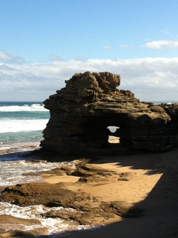
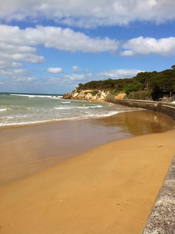 Point Lonsdale Front Beach
The History of our Lands
Our Borough is the land of the traditional owners, the Wada Wurrung people.
Whilst there are few detailed written accounts of how the land would have looked during the 40,000 odd years when the Wada Wurrung had their lands to themselves, we can imagine how it might have been. The following text is fictitious but has been informed by several Aboriginal Cultural Heritage Assessments (ACHAs) of the Borough's lands conducted by Andrea Murphy and Dr Tom Rhymer. Its purpose is to help us imagine how the Wada Wurrung may have used the land and its resources many years ago.
Text Begins:
The Bellarine Peninsula provided a resource-rich environment for the Wada Wurrung. Its environment ranges from grasslands to woodlands, heathlands to reverines/swamps, esturines to marine habitats.
The gentle undulating and open grassland in the Borough would have been easy for the Wada Wurrung to traverse as they moved from one preferred campsite location to another. The plants growing in the grasslands, such as Kangaroo Grass, would have been a good source of food and fibre. The women would have made damper from the grass seeds by grinding them to make flour. The sweet stem bases could have been eaten like sugar cane. The stems and leaves could also be rolled to make a fine thread.
In the Borough’s grassy woodlands, the Wada Wurrung would have used eucalypts as well as smaller plant species including Black Wattle, Moonah Trees, Black Sheoak, Cranberry Heath, Honey Pots, Small Grass Trees, Kangaroo Grass, Austral Bracken and Common Appleberry. These would have been used for food, medicinal and ceremonial purposes.
The hills around the Borough would have provided good views for the Wada Wurrung to stop and look for other Aboriginal groups or animals to hunt. These elevated (high up) areas with good aspects may have also been places for short term stops to repair and maintain hunting tool kits during hunting and gathering expeditions through the region.
As with other Aboriginal groups throughout Australia, hunting was a male- dominated activity. The Borough’s grassy plains and open forests would have been perfect hunting grounds in which to find kangaroos, emus and bustards (large, heavily built birds).
Apart from spearing, animals also would have been caught by the use of fire drives, decoys and noose snares. The Wada Wurrung men would have lit fires around bushes in which animals were hiding and then speared the animals as they tried to escape the fire. They also would have laid noose snares made out of woven material to trap small animals. The noose (a loop) was jerked tight to capture one of the animal’s limbs when it stepped into the noose.
In forested country, possums would have been obtained by men using a stone axe to notch footholds in a tree to reach the nest. The Wada Wurrung men would then kill or stun the animal by hitting it with a club.
Wetlands along the coast and inland would have been a great place to hunt waterfowl using a variety of methods such as snares, throwing sticks and hides (small hiding places in which the men could sit). Both men and women would have fished in the shallow waters, such as Swan Bay and along the Borough's beaches using spears, nets and weirs (in creeks). Along the coast, the Wada Wurrung could have caught seals, salmon and shellfish. The inland waterways and billabongs would have provided the Wada Wurrung with birds to eat (on a seasonal basis). The Wada Wurrung also may have moved to the lands of neighbouring clans at Lake Modewarre and Mirraewuae Swamp for eeling in summer. Gathering of smaller food resources such as molluscs, crayfish, ants, grubs, lizards and Swan eggs would have been predominantly undertaken by women and children.
The geology of the Borough would have been important to the Wada Wurrung. Granite, found in the Borough, would have been used to make axes and grindstones. Greenstone is known to have been the preferred raw material for the production of axes and was widely traded throughout south-eastern Australia. Flint and quartzite were also used for tools.
Text Ends.
 Looking towards Pt Lonsdale lighthouse
When explorers first came into Port Phillip Bay, they considered the Borough to be unoccupied as there was no evidence of dwellings. We now know that there were dwellings, some more permanent and some temporary, built by the Wada Wurrung people who lived here. Their houses and shelters would have looked very different to those familiar to the European explorers. The nomadic lifestyle of the Wada Wurrung meant that they did not build permanent large settlements like the British villages from which the explorers had come, although they did have some permanent structures.
Once immigrants began to settle in Victoria, they realised the issue of who owned our land required consideration. In 1835, John Batman reportedly negotiated two treaties with the Kulin people to 'purchase' 600,000 acres of land between what is now Melbourne and the Bellarine Peninsula. The Borough's lands were included in this treaty.
The Kulin people, however, who were unfamiliar with the concept of written documents and did not comprehend the oral explanation given by Batman and his party as to the nature of the treaties, did not believe they had 'sold' their lands. The Kulin people, like other Aboriginal groups throughout Australia, saw themselves as 'belonging to' the land rather than 'owning' it.
So who did the lands of the Borough now belong to?
On the basis of two documents, Batman claimed the lands were now owned by the Government of Victoria. On the basis of more than 40,000 years of settlement, the Kulin people believed the lands belonged to them.
To ensure British rights to the land, the British Colonial Office issued a proclamation which stated that people found in possession of land without the authority of the Colonial Government would be considered trespassers. In other words, in our Borough the Wada Wurrung people were suddenly declared trespassers on the lands on which they had lived for thousands of years. The proclamation contradicted an 1837 report to the British House of Commons which recognised that Australia's Aboriginal occupants had rights in land.
For more information, please go to: http://australia.gov.au/about-australia/australian-story/european-discovery-and-colonisation.
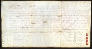 The Batman Treaty 1835
The Batman Treaty
For an interactive display about the Batman Treaty, please visit: http://www.nma.gov.au/engage-learn/schools/classroom-resources/multimedia/interactives/batmania_html_version/the_deed
Please also see:
http://woollydays.wordpress.com/2013/11/23/revisiting-batmans-treaty/
When did we become a Borough?
In 1863 Queenscliff was declared a borough, which included Point Lonsdale. Today it is the smallest local government area in Victoria. It is the only remaining borough in Australia.
For more information, please go to: http://www.heritageaustralia.com.au/search.php?state=VIC®ion=75&view=67
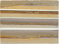 Fred Williams' beachscapes, 1971
What did our lands look like 100 years ago?
Thanks to Queenscliff's Historical Society, we have an insight into what the lands around the Borough looked like in the 1890s. In 1893 a tourists' guide described Queenscliff as being: "prettily situated on a narrow peninsula of high land, having the quiet waters of Swan Bay on one hand, and the changeful sea from Bass' Straits on the other". It described Point Lonsdale as being: "...about four miles beyond Queenscliff, forms one of the headlands at the entrance to Hobson's Bay - the opposite one being Point Nepean. It has a Lighthouse and signal station. There are a few cottages scattered about besides those belonging to the lighthouse, none large except a beautiful gabled house which has been recently erected, and commands a splendid view".
For the full extract of the tourists guide and a fascinating look at what life was like in Point Lonsdale and Queenscliff in the 1890s go to:
- Point Lonsdale: http://zades.com.au/gandd/index.php/bellpen/towns2/plonsd
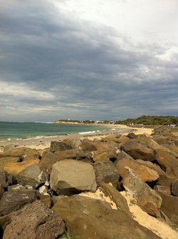
 Point Lonsdale back beach
What do our lands look like today?
The land in Queenscliff is coastal with water on three sides of the suburb. Point Lonsdale has water on two sides. The land is relatively flat, featuring low lying coastal areas. A thin ribbon of land connects Queenscliff to Point Lonsdale.
The Borough's lands consist of:
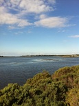
The coastal dune scrub and coastal grasslands are found on those lands running onto the beaches on the Bass Strait side of the Borough. This includes the Point Lonsdale back beach, small pockets at Point Lonsdale front beach and Queenscliff's beaches. Coastal dune scrub normally is 3 m tall with a few taller trees. The soil consists of sands that are subject to high levels of saltspray and continuous disturbance from onshore winds.
This coastal landscape is made up primarily of aeolian calcarenite (headlands) and aeloian sands (notably Point Lonsdale back beach). Aeloian calcernite is a limestone which has been moved by the wind and deposited in the sands around our beaches. The limestone consists of calcareous sand from mollusc shells and other organic remains. Aeloian sands are sands that have been carried by the wind before being deposited on its current site.
The shape of the dunes in the Borough, therefore, are constantly changing as the wind, currents and waves shift the sand from one place to another. Changes to the dune formation can result form severe storms and dramatic rises in tides which can quickly erode the dune system but normally it is a gradual process, so slight you wouldn't know it was happening. For example, a wind speed as low as 16km/hr can lift sand grains from a bare surface and start them moving. In this way, sand at Point Lonsdale front beach travels to the Queenscliff front beach and harbour mouth. This process of slowly changing dune shapes and sizes also shapes the vegetation which grows on and around the dune.
The land in Queenscliff is coastal with water on three sides of the suburb. Point Lonsdale has water on two sides. The land is relatively flat, featuring low lying coastal areas. A thin ribbon of land connects Queenscliff to Point Lonsdale.
The Borough's lands consist of:
- coastal dune scrub/coastal grasslands;
- damp sands herb-rich woodland which has been cleared for farming and housing;
- coastal alkaline scrub; and
- coastal saltmarsh.
The coastal dune scrub and coastal grasslands are found on those lands running onto the beaches on the Bass Strait side of the Borough. This includes the Point Lonsdale back beach, small pockets at Point Lonsdale front beach and Queenscliff's beaches. Coastal dune scrub normally is 3 m tall with a few taller trees. The soil consists of sands that are subject to high levels of saltspray and continuous disturbance from onshore winds.
This coastal landscape is made up primarily of aeolian calcarenite (headlands) and aeloian sands (notably Point Lonsdale back beach). Aeloian calcernite is a limestone which has been moved by the wind and deposited in the sands around our beaches. The limestone consists of calcareous sand from mollusc shells and other organic remains. Aeloian sands are sands that have been carried by the wind before being deposited on its current site.
The shape of the dunes in the Borough, therefore, are constantly changing as the wind, currents and waves shift the sand from one place to another. Changes to the dune formation can result form severe storms and dramatic rises in tides which can quickly erode the dune system but normally it is a gradual process, so slight you wouldn't know it was happening. For example, a wind speed as low as 16km/hr can lift sand grains from a bare surface and start them moving. In this way, sand at Point Lonsdale front beach travels to the Queenscliff front beach and harbour mouth. This process of slowly changing dune shapes and sizes also shapes the vegetation which grows on and around the dune.
Woodlands
The damp sands herb-rich woodlands formed the key landscape in Queenscliff prior to non-indigenous settlement. When European-style houses started to be built in Queenscliff and European farming practices were introduced these woodlands were cleared to make way for residences and farms. Our much-loved moonah trees have survived in some areas around the Borough. These woodlands occur on deep sandy soils and loamy top soils.
The damp sands herb-rich woodlands formed the key landscape in Queenscliff prior to non-indigenous settlement. When European-style houses started to be built in Queenscliff and European farming practices were introduced these woodlands were cleared to make way for residences and farms. Our much-loved moonah trees have survived in some areas around the Borough. These woodlands occur on deep sandy soils and loamy top soils.
Coastal Alkaline Scrub
Coastal alkaline scrub ran across the body of Point Lonsdale, stopping at the beaches where it met coastal dune scrub and near the lakes where it met coastal saltmarsh. Like Queenscliff much of this land has now been cleared to meet residential and farming requirements. Coastal alkaline scrub occurs near-coastal, deep calcareous (alkaline) sand dunes and swales. It normally exists on the landward side of primary dunes. This scrub normally has a layer of medium and small shrubs with sedges, grasses and herbs covering the ground.
Coastal alkaline scrub ran across the body of Point Lonsdale, stopping at the beaches where it met coastal dune scrub and near the lakes where it met coastal saltmarsh. Like Queenscliff much of this land has now been cleared to meet residential and farming requirements. Coastal alkaline scrub occurs near-coastal, deep calcareous (alkaline) sand dunes and swales. It normally exists on the landward side of primary dunes. This scrub normally has a layer of medium and small shrubs with sedges, grasses and herbs covering the ground.
Coastal Saltmarsh
Coastal saltmarsh occurs on and immediately above marine and estuarine tidal flats. It typically consists of a range of life forms including succulent herbs, low succulent shrubs, rushes and sedges. Plants common to coastal saltmarshes include shrubby glasswort, beaded glasswort, creeping brookweed, searush and streaked arrowgrass.
Coastal saltmarsh occurs on and immediately above marine and estuarine tidal flats. It typically consists of a range of life forms including succulent herbs, low succulent shrubs, rushes and sedges. Plants common to coastal saltmarshes include shrubby glasswort, beaded glasswort, creeping brookweed, searush and streaked arrowgrass.
